|
|
|
|
|
|
|
|
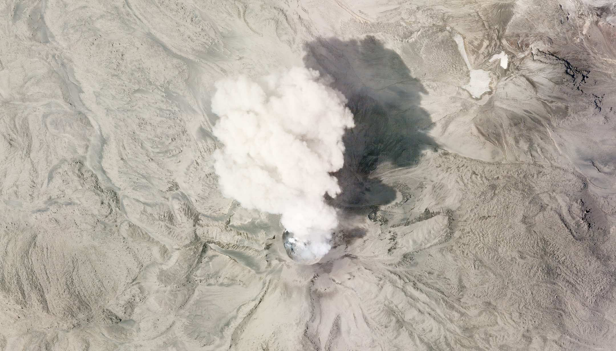 |
SkySat • Sabancaya Volcano, Peru • July 8, 2020 |
In this week’s issue: A curious glacier is examined in Alaska, an eclipse is caught on camera in the Pacific Ocean, tianguis emerge from the streets of Mexico City, potash pools are spotted in the Dead Sea, a sandstone monolith is seen in Australia, and we capture an oblique of Houston in Texas.
This week we’re sharing a collection of mini stories and images that at one point or another have bewildered and amazed us. So take a breather and enjoy this relaxed issue for some sock-knocking images. |
|
|
|
|
What in the world Malaspina Glacier
Certain landscapes look like spilled ice cream melting from its cone onto the sidewalk. And in the case of Alaska’s Malaspina glacier, that analogy isn’t far off. It’s a piedmont glacier: its glacial ice spills from a confined mountain valley to flat land, creating a distinctive wide lobe. So essentially spilled ice cream. Malaspina is the largest in North America partly because it’s made up of 3 lobes from 3 different glaciers (look at the top left and top right corners of the image and you can see the eastern and western lobes). Malaspina is a bit of a celebrity among glaciologists. It’s large, accessible, and has been studied since the 1890s. But it’s on the move. It’s also a surge glacier, meaning it moves rapidly at times. Those distinctive wiggly stripes seen in the center lobe are moraines—rocky ridges— made by its surges. |
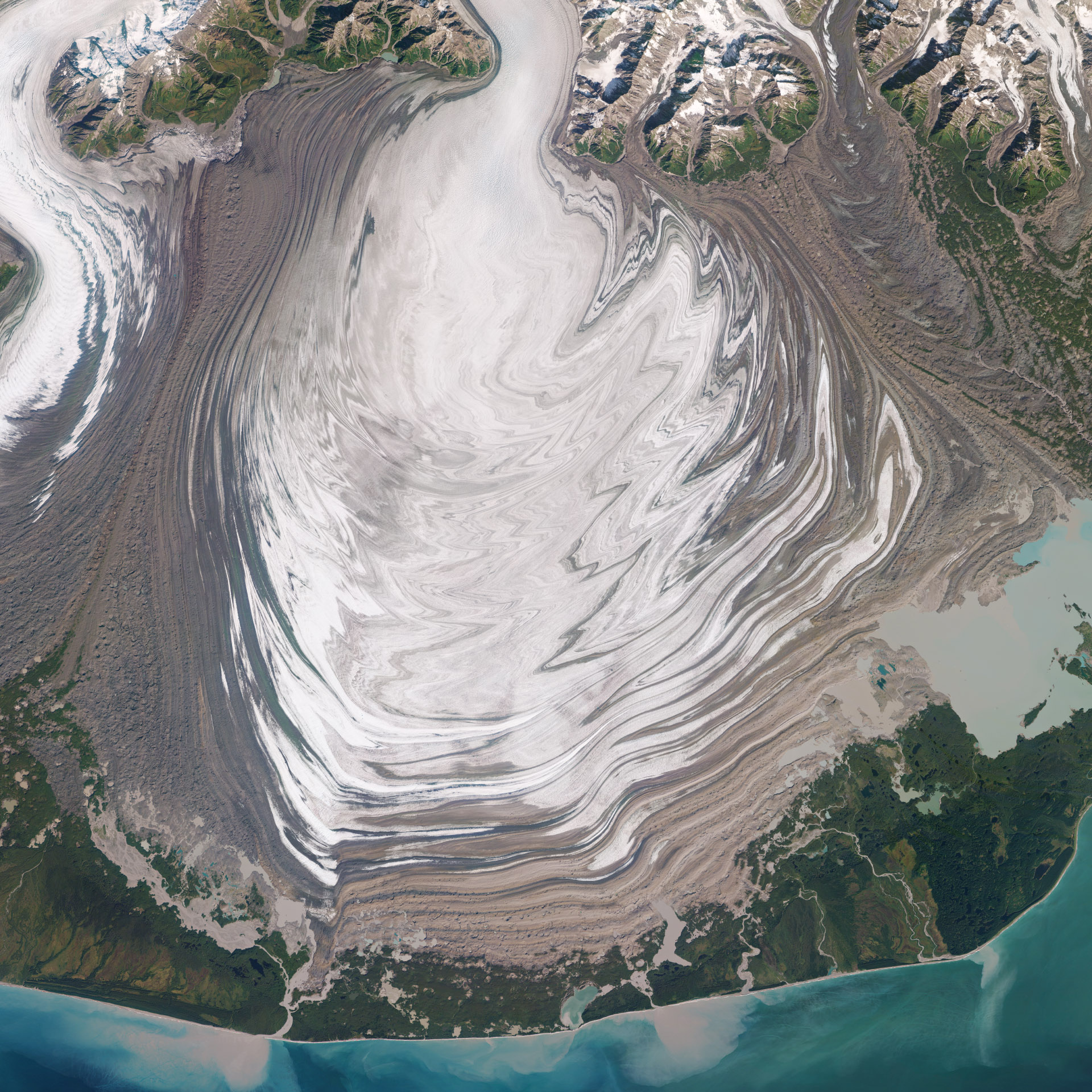 |
RapidEye • Malaspina Glacier, Alaska, USA • September 9, 2018 |
|
|
|
|
Eclipse
Unlike a haunted house, flickering lights across the planet don't indicate a phantom presence. Just that celestial bodies have aligned in rare trajectories. In 2016, one of our satellites was orbiting over the Pacific Ocean when it captured a partial solar eclipse taking place over the small volcanic Pagan Island in the Mariana Island chain. |
 |
PlanetScope • Pagan Island, Marianas Islands • March 8, 2016 |
The image, as you might have guessed, is far darker than you’d expect an early afternoon capture of a sunny island (compare it to this capture of some islands in Indonesia). So the cause is extraterrestrial, but not very spooky. |
 |
PlanetScope • Krakatoa Eruption, Sunda Strait Indonesia • April 25, 2022 |
|
|
|
|
|
Tianguis
The red tarps of Mexico City’s tianguis run along its streets like blood-filled veins. And they are just that, in a sense. Tianguis are informal street markets where vendors sell everything from chorizo to pirated DVDs. They close off entire streets with bustling activity and are as vibrant as they are culturally important. |
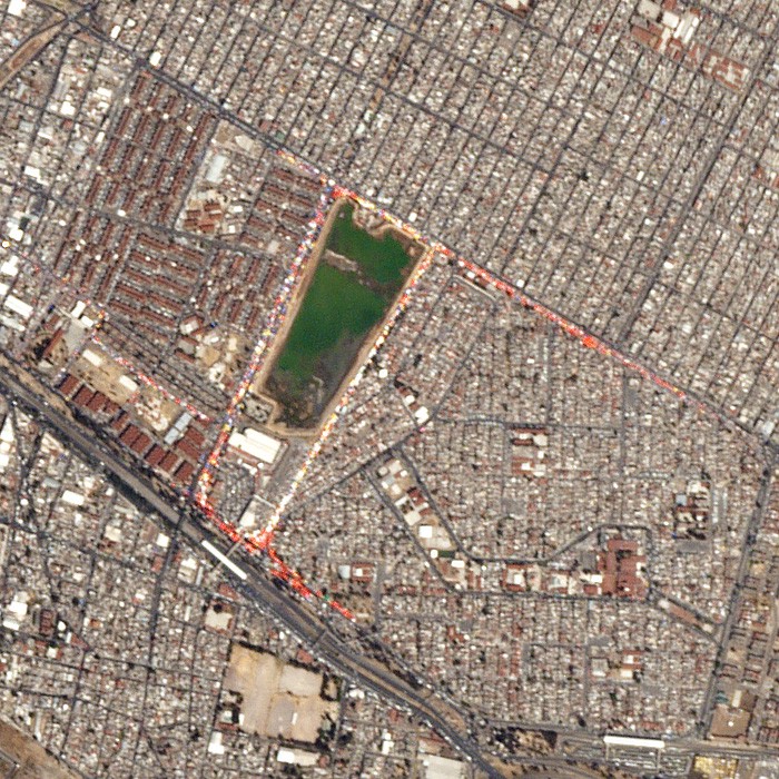 |
PlanetScope • Mexico City, Mexico • February 17, 2016 |
It’s estimated that there are over 1,000 tianguis run by 50,000 merchants in Mexico City. The markets rotate throughout the week, as you can see below in their shifting locations over the days. While the view from space doesn’t capture their bustling energy, it shows how these cultural veins service the city. |
 |
PlanetScope • Mexico City, Mexico • February 17 - 22, 2016 |
|
|
|
|
|
|
|
Potash
Last week, we shared an image of a potash—salts containing potassium used primarily in fertilizers—mine in Utah changing colors throughout the year. We liked the colors, and saying the name out loud, so we're including another one this week. These pools are located right along the Jordan-Israel border in the southern portion of the Dead Sea. The potash here isn’t actually mined, it's extracted from the seawater through evaporation. The salty sea provides a host of minerals and products for commercial use, but its potash creates the striking blue. |
 |
PlanetScope • Potash, Dead Sea • July 4, 2021 |
|
|
|
|
|
|
|
Uluru
We enjoy throwing our geologist readers a bone when we can (do bones count as minerals?). So this week we’ve got an image of Australia’s revered and sacred Uluru, a sandstone monolith over 300 meters (1,000 feet) tall. The rock has held cultural importance for Australian Aboriginal peoples for tens of thousands of years. The top-down perspective from space flattens its iconic height, yet its stature is still discernible. |
 |
PlanetScope • Uluru, Australia • December 3, 2015 |
|
|
|
|
|
|
|
Houston
From the map on your phone to the photos we share here, you’re likely accustomed to viewing the world from space top-down. That is, the satellite view staring straight down from space to surface. It’s the prevalent perspective in remote sensing imagery. And while it’s valuable in most respects, it has a tendency to make the Earth appear unusually 2D. But we’re used to viewing the world in 3 dimensions. So if you want to make the topography, structures, and cities that cover Earth’s surface pop, then tilting the camera to produce an oblique angle is your best shot. Take a look at how the Houston skyline emerges from this perspective. And if you’re interested in seeing more oblique images—and learning more about them—then check out our satellite explainer on them. |
 |
SkySat • Houston, Texas, USA • March 14, 2018 |
|
|
|
|
|
|


