|
|
|
|
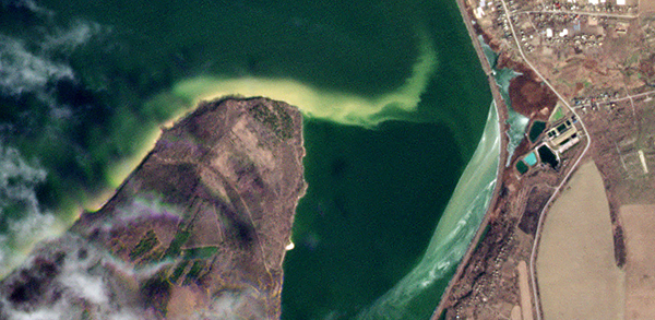 |
PlanetScope • Damage and spillage at wastewater treatment plant, Vasylivka, Ukraine • March 15, 2022 |
In this week’s issue: We take a look at how satellite imagery has been used to illustrate, inform, and verify news stories from June around the world, a potash mine showcases some stylish colors in Utah, and a geological oddity emerges from the Sahara in Mauritania. |
|
|
|
FEATURED STORY
June News Breakdown
As we enter the summer holidays, perhaps you’re hoping to unplug from the endless onslaught of information we’ve come to call the news. We don’t blame you if you are—its cycle has been particularly heavy and lengthy as of late. But if you’re curious how satellites help illustrate and inform the news, then stick around. We’ve rounded up and broken down some of the most impactful stories from June that utilize satellite imagery to help their message. And while we can’t promise light material for all of them, we can promise brevity. So let’s get to it.
In mid June, heavy rain and swiftly melting snowpack caused severe flooding to sweep through Yellowstone National Park. The torrent pulled houses into rushing water, knocked down bridges and roads, and rerouted entire rivers off course (see image below). While images of the destruction look grim, some journalists have noted the regenerative aspects of flooding in landscapes designed for disruption: creating new habitat, seeding tree species, and benefiting trout populations. Yet still, the park and local communities are reckoning with how to handle the impacts of climate change and a greater frequency of formerly-called thousand-year-events.
| 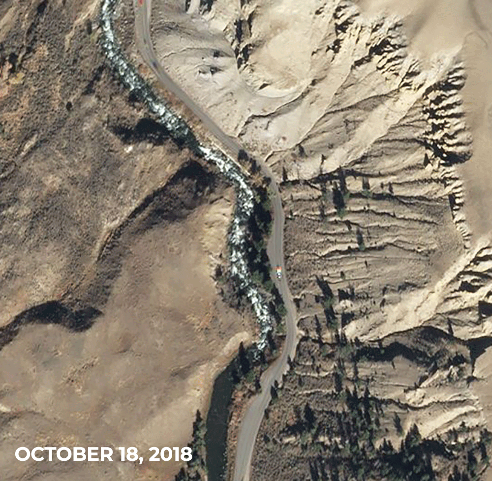 | SkySat • Rerouted river, North Entrance Road, Yellowstone National Park, Montana, USA • October 18, 2018 - June 22, 2022 |
You might not expect the world’s second largest wetland to catch fire easily. But in February, many parts of the Iberá Wetlands lit like tinder. The area has been affected by a longstanding drought that's lowered water levels, and scorching temperatures made Argentina the hottest place on Earth in January. The wetland reserve is part of a three-decade effort to rewild Argentina. And the fires this year presented another setback to an already uphill battle. The Guardian published a story about the mission to rewild these lands and used satellite imagery to show how forces like deforestation, development, and wildfires are threatening their work.
|  | PlanetScope • Iberá Wetlands, Argentina • January - May, 2022 |
Since Russia began its invasion of Ukraine in February, the international community has pursued a multi-pronged sanctioning of its various enterprises, from oil imports to debt payments. For Russia’s ultra-rich, however, the crackdown has focused on their ultra high wealth assets—and where those yachts and private planes can travel. The New York Times analyzed flight patterns to understand how these elite lifestyles have changed in the wake of restrictions. Their findings show an unmistakable new hub: Dubai. Satellite images of Al Maktoum International Airport show an increase of parked airplanes and private jets between February and March, 2022, helping to illustrate this shifting pattern.
| 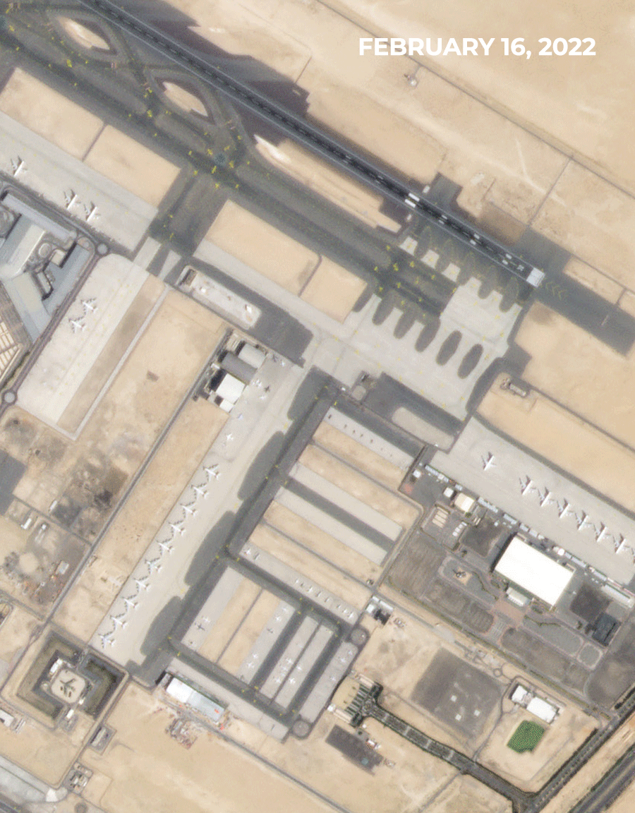 | PlanetScope • Al Maktoum International Airport, Dubai, UAE • February 16 - March 31, 2022 |
Reporters at Reuters investigated the jailing of ethnic Tigrayans as Ethiopia's Tigray War enters its 20th month of conflict. They’ve found that thousands of Tigrayans have been jailed in unsanitary makeshift prisons that are rife with mistreatment. Reuters used satellite imagery to confirm on-the-ground reports of conditions at the prison and made a timelapse to show the development of one at a Soloda College between December 2021 and February 2022. Over the months an increase in blue tarpaulins and makeshift structures can be seen crowding the college.
| 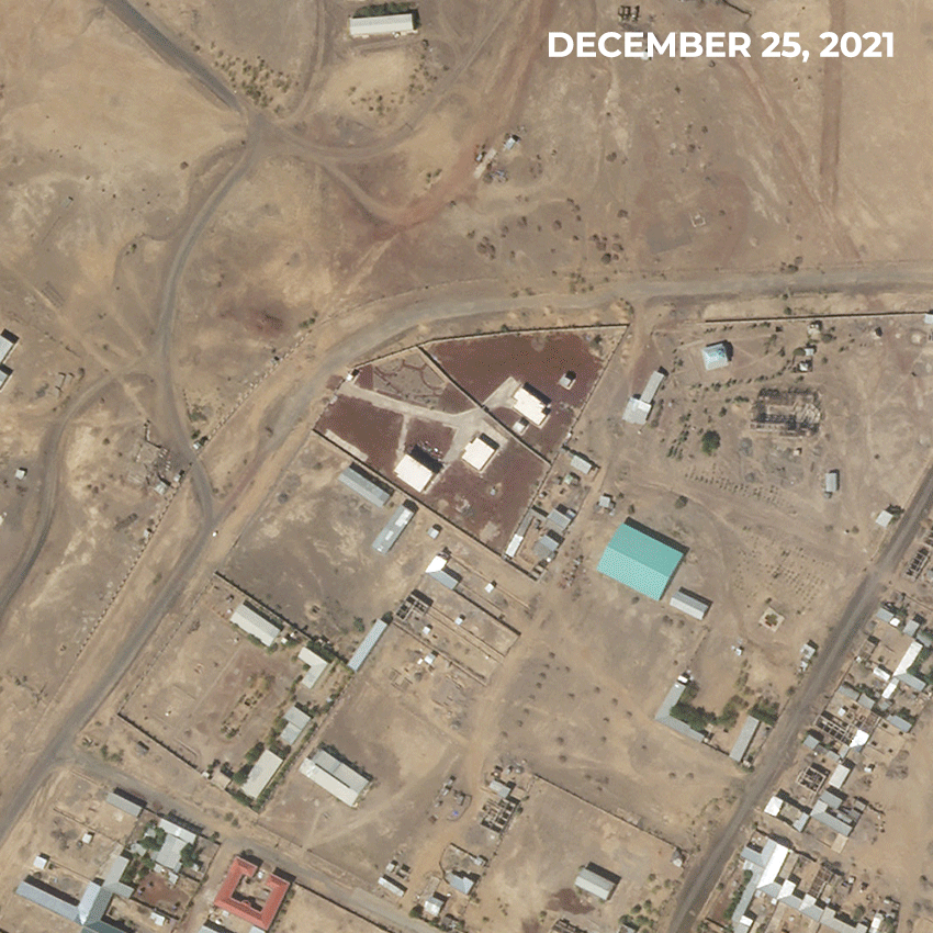 | SkySat • Samera, Ethiopia • December 25, 2021 - February 5, 2022 |
In a groundbreaking investigation, the Financial Times tracked a ship named the Fedor as it moved from port to port across the Black Sea. The Fedor officially claimed that its cargo—9,000 tonnes of corn—came from Russia, where there are no sanctions on food exports. Shipping out of Crimea, however, is illegal for many companies. Reporters at the Financial Times analyzed satellite imagery to establish that the Fedor’s cargo was in fact picked up in Sevastopol, Crimea, where the ship—seen docked in the middle of the image near the grain terminal complex—appears to be filled with grain. While it’s not confirmed that the corn was stolen from Ukraine, the evidence suggests that Russia is evading sanctions by conducting commerce on the Black Sea.
| 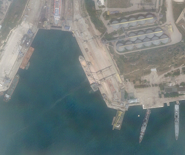 | SkySat • Grain Terminal, Sevastopol, Crimea • June 12, 2022 |
Russia abandoned its outpost on Snake Island in the Black Sea after months of targeted Ukrainian bombardment, according to multiple reports last week. The small island has been contested as a strategic foothold for both sides since Russia invaded Ukraine in February. Russia is blockading Ukraine’s access to the Black Sea as part of their offensive strategy to prevent exports of grain. The reclamation of the island weakens Russia’s position and could help Ukraine disrupt their shipping lanes.
| 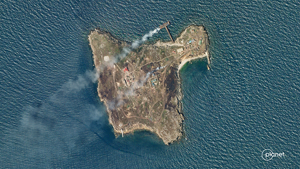 | SkySat • Snake Island, Ukraine • June 29, 2022 |
|
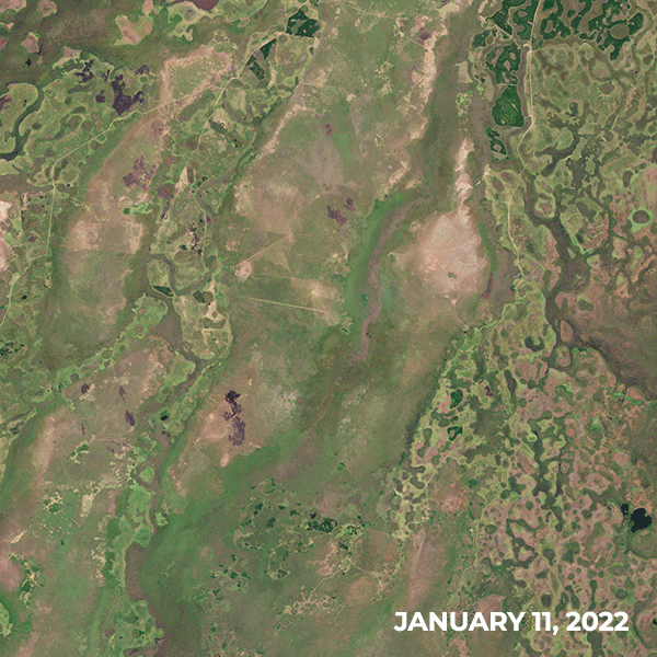
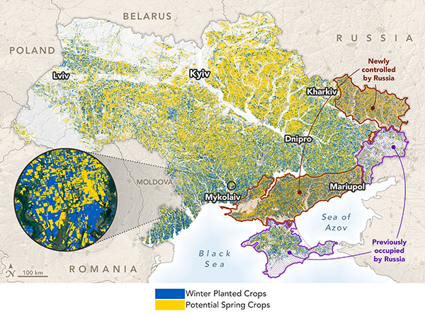
NASA Harvest and other NASA-funded scientists are using satellite-based techniques to survey commodity crops and improve agricultural decision-making. Recently, the group processed and analyzed data from Planet and ESA’s Sentinel-2 mission to display the distribution of Ukrainian summer and winter crops. Their analysis shows that around 22% of the country’s farmland is now occupied by Russia. But while overall yield forecasts look promising given the circumstances, increases in global food prices and Russia’s naval blockade are creating challenges for farmers.
|  | Map analytics by NASA Harvest • Source data by Planet and ESA Sentinel-2 |
Though Yellowstone received prominent coverage in June, flooding has recently impacted many regions across the world. Record rainfall befell parts of southern Austria last week, overflowing rivers and triggering mudslides. The thunderstorms that triggered them rode on the heels of a historic heat wave that spread across Europe in June. Our satellites captured the impact of one of these debris flows in the Austrian town of Treffen.
| 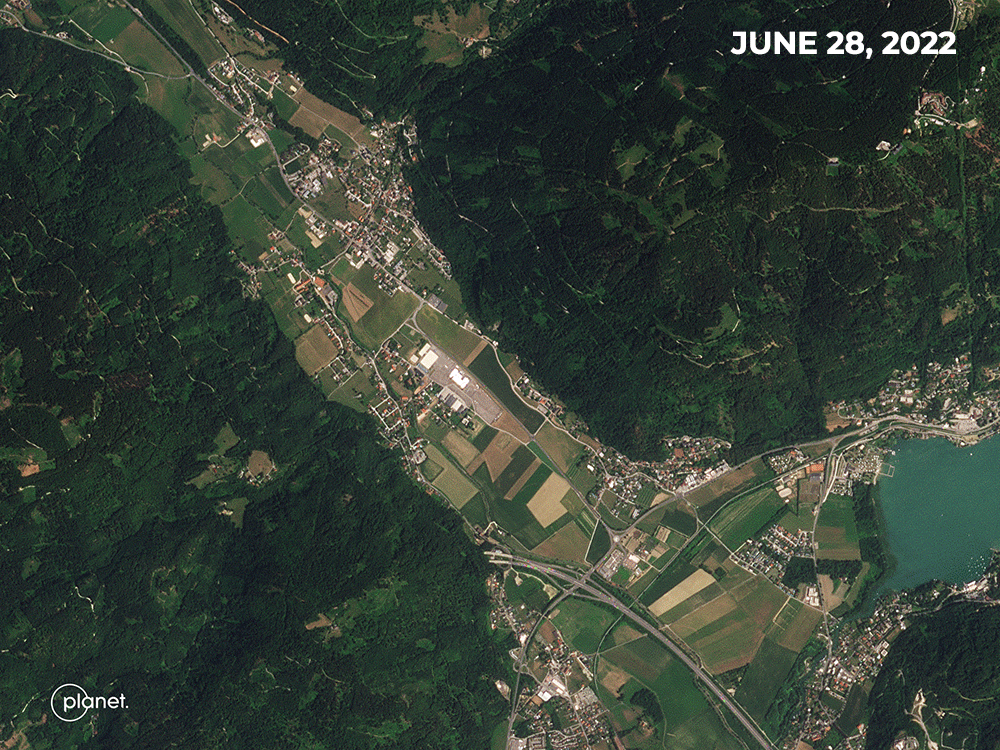 | PlanetScope • Treffen, Austria • June 28 - 30, 2022 |
There’s too much nitrogen in New York’s Shinnecock Bay, but sugar kelp is up for the task of removing it. In June, Mongabay shared the story of the US East Coast’s first Indigenous-owned kelp farm. It’s managed by six women from the Shinnecock Nation who are hoping to build a large network of kelp farmers to help mitigate damages like ocean acidification and excess nitrogen.
| 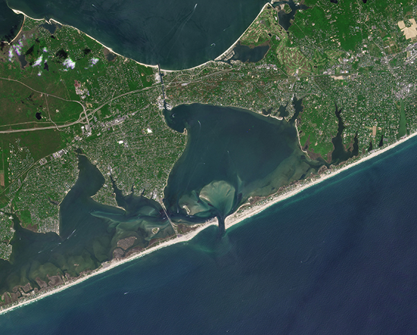 | PlanetScope • Shinnecock Bay, New York, USA • May 30, 2022 |
|
|
|
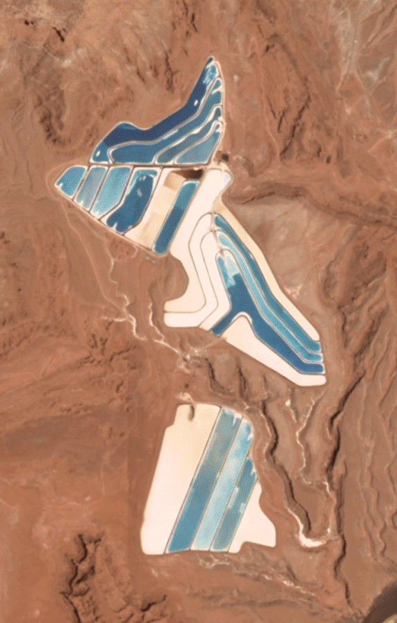
Change of the Week: Desert Disco
Electric blue is unlikely a color you’d expect among the red rocks and sands of Moab, Utah. Yet nestled between the area’s iconic geological formations is a potash mine as blue as a blueberry. Potash is a salt containing potassium made by drying potash ore over 300 days in the ponds seen below. The evaporation pools are dyed blue since darker colors absorb more sunlight and heat, thus expediting the process. The varying colors represent different stages of the evaporation process. So when you create a timelapse of them over its 300-day cycle, like Overview did in a recent Instagram post, you get a pretty groovy color rotation.
|  | Created by Overview • Source Imagery from Planet |
|
|
|
|
What in the World: Eye of Africa
Were you to walk among the rock formations of Mauritania’s Richat Structure, you may not find anything particularly notable. But view it from space and its remarkable concentric pattern emerges. The Richat Structure is called the “Eye of Africa” and indeed looks like a giant eye disguising itself as an impact crater. However, it’s actually neither. It’s an uplifted dome created by erosion. And like the rings of a tree, the rocks in the center of the structure are older than those towards the edge. Besides looking awesome, and somewhat intimidating, the 40-km (25-mile) wide structure has been used as a geographical landmark for astronauts passing high above.
| 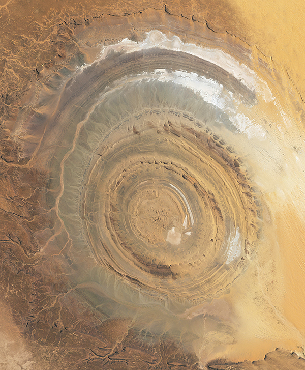 | RapidEye • Richat Structure, Mauritania • January 20, 2019 |
|
|
|
|
|