Planet Snapshots DECEMBER 9, 2021 Issue #5
|
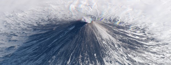 |
| SkySat image of Klyuchevskaya Sopka, Russia, March 11, 2018. |
| In this week’s issue: A bushfire in the Australian Outback takes an interesting shape, container ships idle outside major U.S. ports, and satellites view Earth from an angled perspective. |
|
|
|
|
FEATURE STORY Fire Fractals
|
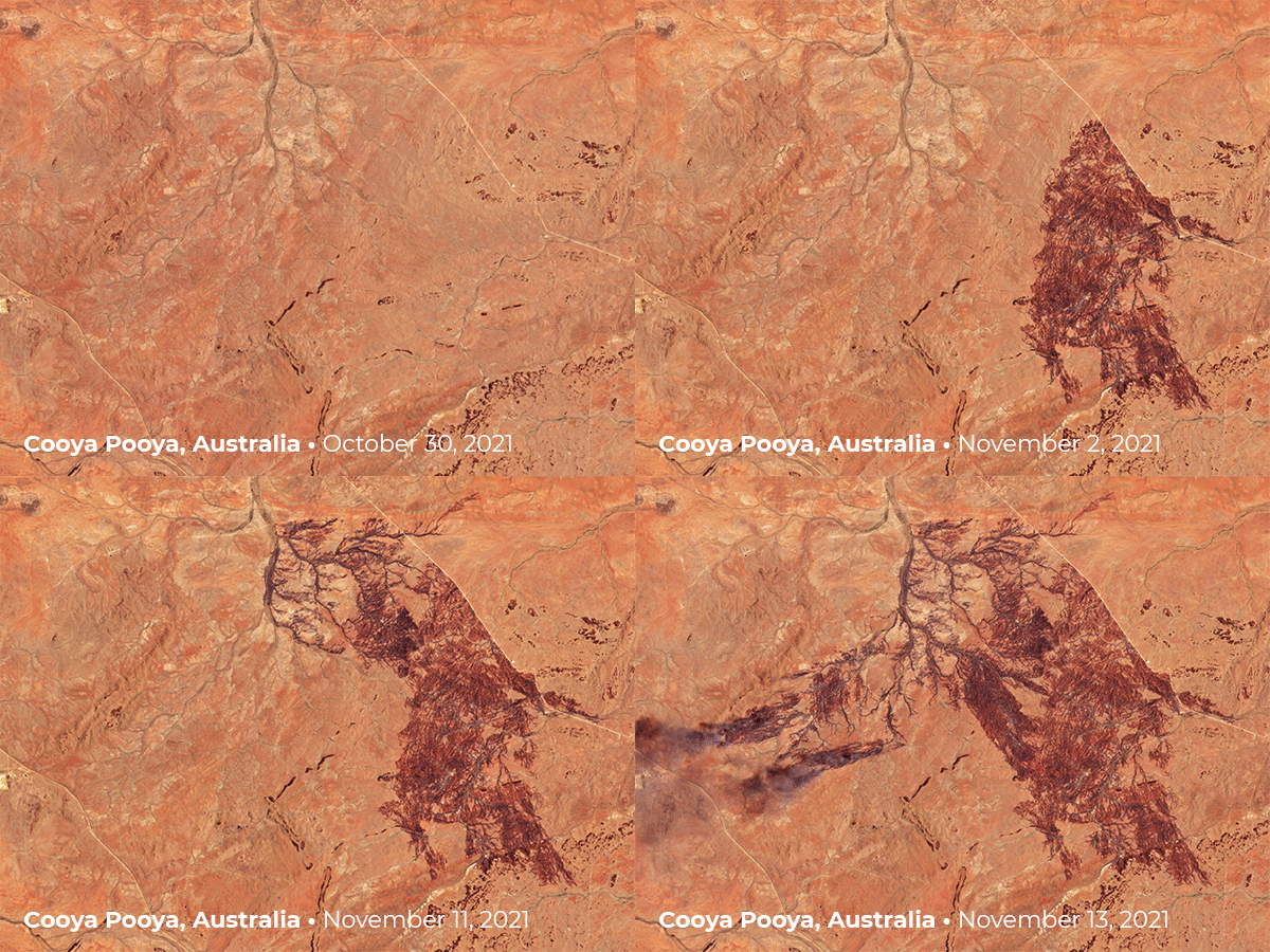 |
| PlanetScope images of Cooya Pooya, Australia. |
| Unlike an ice queen's frozen crystals, it seems there's another power busy making fire fractals in the desert. A wildfire, as its name suggests, is a chaotic and erratic force. While they certainly can be unpredictable, sometimes they follow clear paths. We spotted Rohan Fisher’s Twitter post about a bushfire burning in the Australian Outback and decided to take a look for ourselves. The four images track the fire’s branch-like progression through October and November (spring in the Southern Hemisphere). Referencing a Sentinel-2 image, Fisher comments that the fire is flowing with the fuel and following drainage paths.
One of our favorite activities at Planet—besides eating pancakes—is spotting natural fractal patterns from above. Email us your favorite Earth fractals for a chance to be included in an upcoming special Snapshots issue on viewing fractals from space!
|
|
|
|
|
|
|
|
|
| PlanetScope image of container ships outside the Ports of Long Beach and
Los Angeles, October 19, 2021. |
| Still haven’t purchased those winter gloves for your relative? You may want to consider knitting them yourself. The Covid-19 pandemic has disrupted global supply chains, creating major transportation and inventory issues. Demand lowered for some purchases like vacation-spending, but has increased for others like home goods. This means that many late shoppers may be in trouble for the holidays. The two largest ports in the U.S., Los Angeles and Long Beach, manage over 20% of all incoming cargo for the country. In October, supply chain disruptions created a backlog of over 80 container ships awaiting entry as companies seek to refill their inventories. While the number has dwindled to only 46 ships in the San Pedro Bay as of early December, an estimated 50 vessels are anchored farther out in the open ocean. If you’re ordering anything online, you should probably stop reading and get to it!
|
|
|
|
|
Satellite Explainer: Skewed Views |
| For centuries visual artists have grappled with the problem of how to accurately represent 3D images through 2D mediums. In the early 15th century, artists started using vanishing points to create senses of depth in their illustrations. More recently, photography has enabled us to capture images that resemble reality closer than ever before. But these tools have their limits. And when you’re imaging Earth from hundreds of kilometers in orbit, perspective has a huge impact on final representation. |
 |
| SkySat image of Mount Fitz Roy, Patagonia, March 19, 2018. |
| Satellite imagery of Earth can be shot from two perspectives: nadir or oblique. Nadir is the top-down perspective that’s ubiquitous in the remote sensing industry, from Google Maps to weather forecasts. However, the human eye is not accustomed to viewing the world in 2D. Nadir satellite imagery is incredibly informative. But this perspective eliminates many visual details like depth, which can make the Earth look unnaturally flat (sorry, Flat Earthers). |
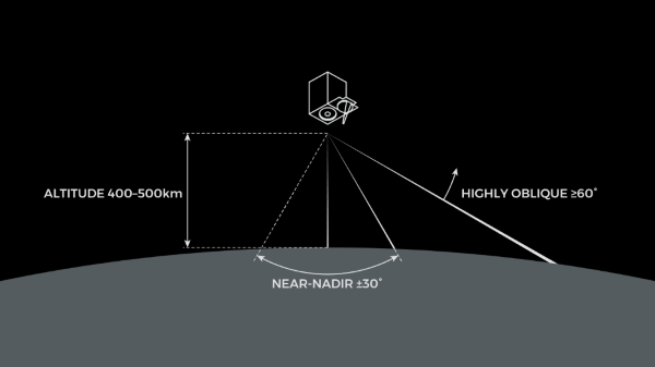 |
| Angle comparison for near-nadir and oblique satellite imagery. Image credit: Robert Simmon. |
|
|
|
|
| SkySat images of Manhattan’s southern tip, New York, September 7, 2021. |
| On the other hand, oblique imagery—roughly taken at an angle greater than ±30°—introduces a perspective that’s more in line with how we see in real life. Compare these two images of Manhattan’s southern tip. While it might be easier to navigate using the first image, the nadir perspective reveals no information about relative building height. Like the painters of old, these angles introduce topographical details that better align with human sight and experience. |
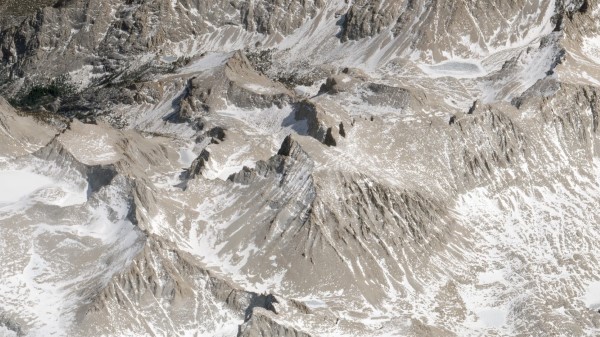 |
| SkySat image of Mount Whitney, California, April 4, 2021. |
| Besides looking extraordinarily cool, oblique imagery also has a number of practical applications. Heights of objects can be measured by capturing different angles of the same landscape. And combining nadir and off-nadir imagery allows users to construct 3D models of mountains, buildings, and other structures.
|
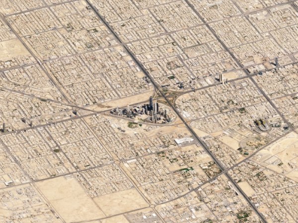 |
| SkySat image of Riyadh, Saudi Arabia, March 10, 2018. |
| For a more comprehensive look at oblique imagery (and other great historical and recent images), check out Robert Simmon’s
Medium post!
|
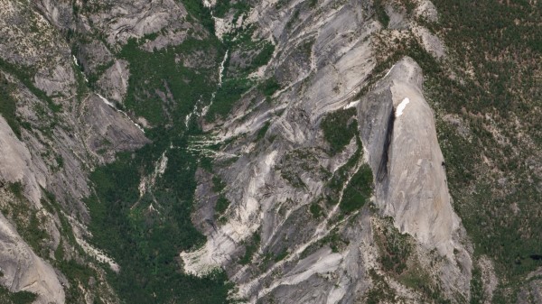 |
| SkySat image of Half Dome, Yosemite Valley, California, June 18, 2019. |
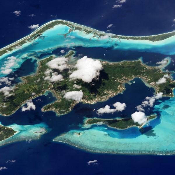 |
| SkySat image of Bora Bora, French Polynesia, March 9, 2018. |
|
|
|
|
Big News: Planet Goes Public! |
|
|
|
|
| Photo of Planet’s early days and recent 10 year anniversary. Image credit: Will Marshall. |
| Planet has gone public! Yesterday, Planet officially started trading on the New York Stock Exchange as a Public Benefit Corporation (stock ticker: PL:NYSE). It’s been a long journey since the company was founded in a garage ten years ago, but we’re excited for the (orbital) road ahead! Ad Astra! |
|
|
|
|
|