Planet Snapshots
NOVEMBER 18, 2021
Issue #3
|
 |
|
PlanetScope image of Upernavik Glacier, Greenland on July 25, 2021.
|
|
In this week’s issue: glaciers in motion, gold mine expansion threatens orangutans, and Qatar hosts a Formula 1 grand prix.
Quick note: Snapshots will be off next week but
catch us for the next issue on December 2nd.
We hope you all have a great Thanksgiving!
|
|
|
|
|
FEATURE STORY
Melting Giants
Canary in the coal mine: The world’s glaciers have long been viewed as an early warning system for increases in global temperature.
Visually—and physically—they’re cool.
But satellite images taken over the past few decades tell a concerning story of decline, retreat, and instability.
These slow-moving masses of ice are vestiges of Earth’s last ice age that have shaped the planet’s crust during their millenia-long voyages.
Today, over 150,000 glaciers cover about 10% of Earth’s landmass and provide local ecosystems an abundance of
benefits, from fresh drinking water to hydroelectric power.
However, these services, along with many others, are dripping away.
|
 |
|
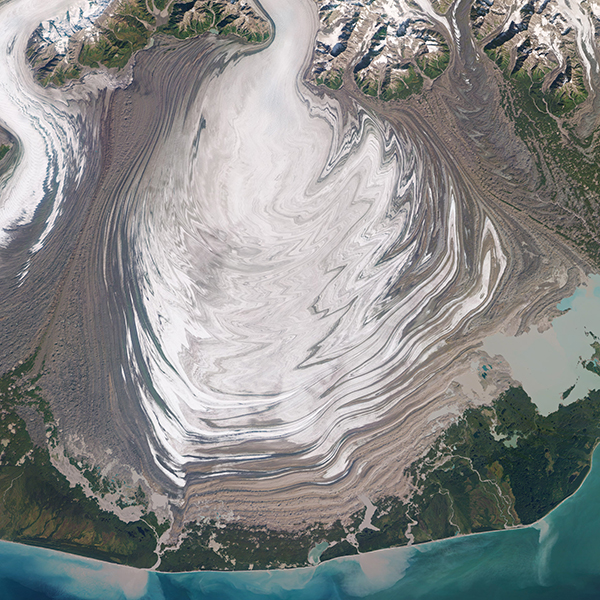
RapidEye image of Malaspina Glacier, Alaska, September, 2018
|
|
The world’s glaciers have melted significantly since the Industrial Revolution.
And in recent years this rate has accelerated.
Data shows that Earth is losing 1.2 trillion tons of ice each year.
This loss is particularly troubling for sea level rise.
If all the glaciers in the world melted, sea level would increase by more than 230 feet (70 meters).
If that doesn’t sound bad, consider that a 10 foot (3 meter) increase would displace 12.3 million people in the U.S. alone, not to mention innumerable
cascading effects.
|
 |
|
Oblique SkySat image of small glaciers on the peak of Mount Kenya, Kenya, March 16, 2020.
|
|
Melting glaciers are an obvious sign of climate change.
When snowfall increases they expand and thicken.
And as the world warms, they melt and retreat.
Historical photos dating back to the 1800s are compared with more recent images, often showing drastic variations in the landscape.
The emergence of satellite imagery has revolutionized our ability to monitor and compare these changes, beginning with the launch of Landsat 1 in
1972.
|
 |
|
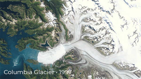
Columbia Glacier, Alaska, 1997 - 2021.
The first three images were
captured by Landsat and the most recent by SuperDove.
|
|
For nearly 50 years scientists have recorded a prolific aerial archive of glaciers during this period of rapid warming.
Perhaps the most visual display of change is that of the glacier’s terminus, or its end point.
As glaciers slowly move, their termini changes, lengthening with more snowpack and receding when temperatures warm.
Since 1982, the Columbia Glacier in Alaska’s Prince William Sound has rapidly retreated, losing as much as 13 million tons of ice a day.
In the images above, its terminus can be seen steadily retreating over the past 24 years.
|
 |
|
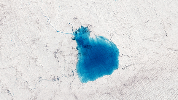
SkySat image of Lake Niels, Greenland, July 29, 2019.
|
|
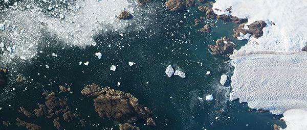
Meltwater lakes are another clear indicator of warming temperatures.
They form when ice melts on the surface of glaciers and ice sheets, often looking strikingly blue like this one spotted on the Greenland ice sheet.
These pools can thin the ice and accelerate further melting.
|
 |
|
Upernavik Glacier, Greenland.
|
|
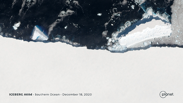
Icebergs are made when ice chunks detach from the termini of glaciers or the ends of ice sheets.
Some can reach enormous sizes.
The A-76 iceberg that broke off Antarctica’s Ronne Ice Shelf earlier this year was 80 times larger than Manhattan.
While calving is a natural process, warmer ocean temperatures can increase its rate, which further contributes to sea level rise.
|
 |
|
PlanetScope image of Axel Heiberg Glacier, Antarctica, August 15, 2019.
|
|
The warning light on Earth’s freezer has turned on.
Increasing global temperatures continue to melt away this critical reserve of freshwater and past climate information.
And even though we sometimes find interesting secrets in the
thaw, it’s better to keep the freezer cool instead of flooding the house.
|
 |
|
|
|
|
Gold Mines and Cinnamon Orangutans
|
|
|
|
|
|
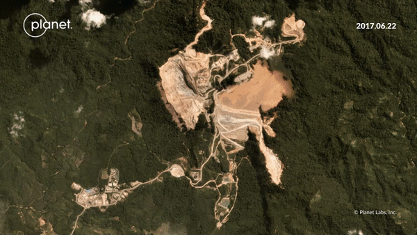
PlanetScope images of the Martabe gold mine, North Sumatra, Indonesia.
|
|
Shady developments aren’t panning out well for an ancient species.
Continued expansion of the Martabe gold mine is threatening the cinnamon-colored Tapanuli orangutans, according to reporters at the Financial Times.
The mine is located in North Sumatra’s Batang Toru forest, 1,100 square km of which serves as the primary habitat for the fewer than 800 Tapanuli orangutans that still live there.
The species is the latest classification of ape and is listed as critically endangered by the International Union for Conservation of Nature (IUCN).
The open pit Martabe gold mine covers over 1300 square km and is managed by an Indonesian unit of Jardine Matheson, a Hong Kong-based multinational conglomerate company.
Last year Jardine and the IUCN settled on an agreement to halt development until its impact on the Tapanuli orangutan could be further studied.
Satellite images, however, have shown the mine expanding during the negotiations.
|
|
|
|
|
Pit Stop in Qatar
|
 |
|
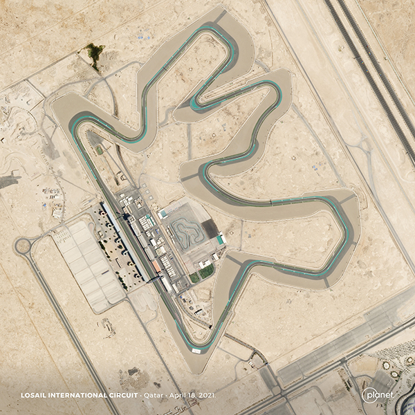
Flags down: Formula 1 racers are heading to Qatar for the Grand Prix this weekend to close out the final round of a triple header.
It will be the first time the 5.3 km Losail International Circuit will host a F1 event.
The track was originally designed for motorcycle racing and is defined by a series of medium and high speed corners.
Want to see more satellite images of the world’s Formula 1 race tracks? Planet’s Rob Simmon has just the article for you.
|
|
|
|
|
Photography Feature: Tom Hegen
|
 |
|
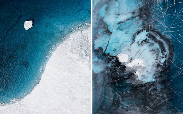
Images fromTwo Degrees Series, Greenland, 2018.
Credit: Tom Hegen.
|
|
In 2015, 197 countries signed The Paris Agreement with the goal of keeping global warming to below 2°C compared to pre-industrial levels.
In his Two Degrees Series, aerial photographer Tom Hegen explores the effects of global warming on the Arctic Ice Sheet.
Take a look at the project and more of his gorgeously devastating images on his website.
|
|
|
|
|
What We're Reading
-
First-Light: NASA and USGS’s latest Earth-imaging satellite, Landsat 9, released its first images of Earth, and they’re nothing short of stunning.
-
Views of Change: As global talks conclude at COP26 in Glasgow, Gavin Schmidt, a senior climate adviser at NASA, published a New York Times visual opinion piece examining the view of climate change from satellite images.
- Transparency: The Washington Post reports on the space race that’s enabling real-time emissions monitoring and the need for reliable and global data sets to meet climate agreements.
|
|
|
|
|