Planet Snapshots
NOVEMBER 11,2021
Issue #2
|
 |
|
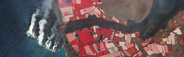
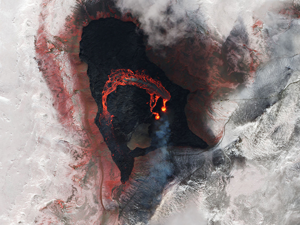
SkySat image of Cumbre Vieja's eruption on La Palma, Spain.
|
|
In this week’s issue: A Spanish volcano surpasses 50 days of activity, palm oil data refutes Malaysia’s emissions report, and a video of Dubai from orbit.
|
|
|
|
|
FEATURE STORY
50 Years Later, 50 Days In
After a 50-year hibernation, Cumbre Vieja is rumbling.
The volcano on the island of La Palma in Spain’s Canary Islands reached its 50th day of activity on Monday after first erupting on September 19th.
Over the past few weeks lava has covered hundreds of hectares of land as it flows towards the ocean, destroying thousands of buildings and forcing residents to evacuate their homes.
Yet the volcano shows no signs of slowing down as new lava streams emerge and tectonic activity persists in the region.
|
 |
|
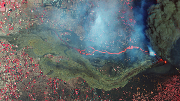
SkySat image of Cumbre Vieja’s eruption on La Palma, Spain, September 26, 2021.
|
|
A torrent of satellite imagery has tracked the eruption’s development in recent weeks:
|
 |
|
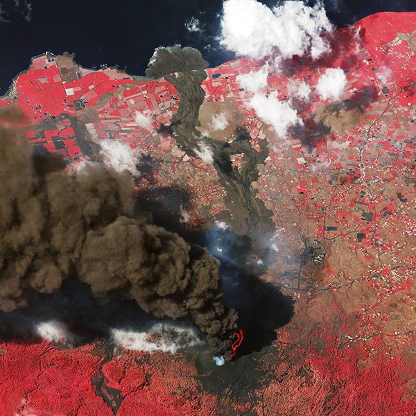
SkySat image of Cumbre Vieja’s eruption on La Palma, Spain, October 4, 2021.
|
|
Last month, we captured this oblique image—taken at a non-vertical angle—to show the eruption’s smoke plume, emerging rivers of lava, and its descent to the Atlantic all in one frame.
Infrared data was combined with natural-color imagery to highlight surfaces that also emit light, as seen in the glowing streams of hot lava.
Preparing for impending eruptions is critical for regional safety, and remote sensing is a powerful way to keep an eye on volcanic activity.
Of the roughly 1,500 active volcanoes on Earth only 50% are monitored from the ground.
Satellites can survey precursors to volcanic eruptions among even the most remote areas, providing local authorities valuable information to act upon.
It often takes a distant view to recognize the immense and terrifying power of active volcanoes.
Over the years we’ve monitored these eruptions, from incandescent lava streams to the destructive trails of debris they leave behind:
|
 |
|
SkySat image of Fagradalsfjall volcano in Iceland, March 26, 2021.
|
 |
|
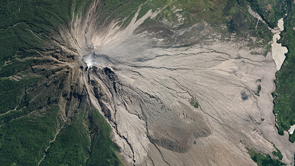
SkySat image of Mount Sinabung stratovolcano in North Sumatra, Indonesia, June 29, 2019.
|
|
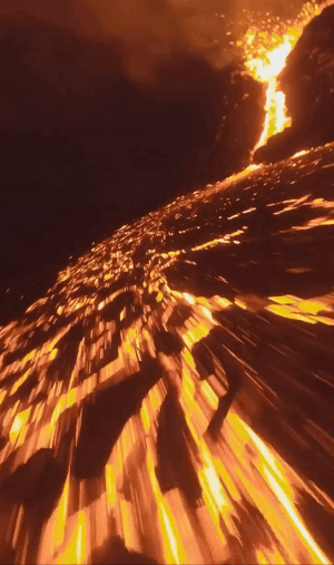
Sometimes, however, a closer look—but not too close!—lets you truly appreciate the lifeblood of Earth.
@IcelandAerials flies drones over active volcanoes and takes mesmerizing videos.
|
 |
|
Drone footage of a volcano.
Image credit: @IcelandAerials
|
|
|
|
|
Strong Claims, Inconsistent Evidence
|
|
|
|
|
|
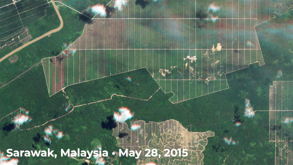
PlanetScope and RapidEye images of a palm oil plantation in the Sebauh district of Sarawak, Malaysia.
|
|
The stats don’t match the facts: A Washington Post investigation revealed significant discrepancies between countries’ declared emissions and their actual contributions to atmospheric greenhouse gases.
This week, world leaders are signing climate pledges and setting emissions targets at COP26.
The problem is that pledges built on faulty data will yield faulty results.
Although discrepancies affect all countries that report their emissions to the United Nations, one of the most acute examples of underreporting highlighted is that of Malaysia and its carbon-rich peatlands.
In 2016, the country claimed to have not converted any cropland to palm plantations, a process that releases significant amounts of atmospheric CO2.
The data says otherwise.
Independent researchers used satellite maps to discover over 400,000 acres of new palm oil plantation development in 2016 alone.
The time-lapse above shows a section of this expansion from 2015-2021, underscoring the need to use reliable datasets when constructing actionable pledges.
|
|
|
|
|
Overlooking Giants
|
 |
|
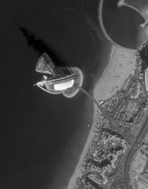
SkySat video of Burj Al Arab hotel, Dubai,
United Arab Emirates, 2019.
|
|
Our SkySats are known for their static images, but occasionally we tap ‘record’ to get a video from orbit! This clip was taken over the Burj Al Arab, a luxury hotel constructed on an artificial
island in Dubai, United Arab Emirates.
Though it looks small here, the building stands 689 feet (210 meters) tall!
Take a look at SkySat’s full video here.
|
|
|
|
|
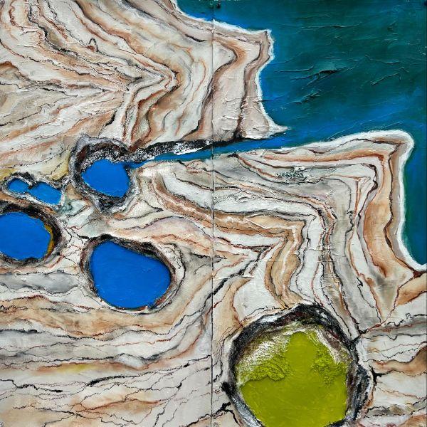
The Earth is Breaking Beautifully
|
 |
|
‘The Earth is Breaking Beautifully’, 30x30”, by Susan Hoffman Fishman
|
|
Despite its name, the Dead Sea is teeming with motion.
Climate change and damming along the Jordan River have caused parts of the region to rapidly dry, resulting in the formation of thousands of sinkholes.
Minerals from the ground color water in the holes cobalt blue, lime green, yellow ochre, and sepia.
Susan Hoffman Fishman, one of Planet’s Artists in Residence, is captivated by this contrast between the danger caused by the sinkholes and the beauty of the devastation.
Her first painting as part of the program, ‘The Earth is Breaking Beautifully,’ is shown above.
|
|
|
|
|
In the News
-
Extra serving of kelp: The San Francisco Chronicle reports that a bull kelp forest off of Northern California’s coast has doubled in size since last year, according to satellite and drone research.
-
Whose tanker?: Satellite imagery spotted a Vietnamese-flagged oil tanker off the coast of Bandar Abbas, Iran, but the ownership of the vessel is raising flags of its own, reports The New York Times.
- The path ahead: Thomas L.
Friedman reflects on COP26: the role of Gen Z in the climate movement, the importance of Indigenous communities and biodiversity, and the value of powering climate transparency with satellite data.
|
|
|
|
|