|
|
|
|
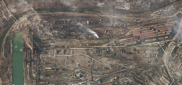 |
SkySat • Azovstal Steel Plant, Ukraine • March 24, 2022 | In this week’s issue: An interview with open-source researcher Wim Zwijnenburg about the role of OSINT in conflicts.
CW: Some images may be upsetting for readers: violence, mass graves.
|
|
|
|
FEATURED STORY
100 Days in Ukraine
This weekend marks the 100th day of Russia’s invasion of Ukraine. It’s a grim milestone marked by months of horrific stories, brave acts, and global repercussions. But the question of how it ends remains unanswered.
The future of war is uncertain. That’s always been true. What’s different this time is the transparency with which the world watches Russia’s offensive unfold. The proliferation of and accessibility to open-source intelligence (OSINT) tools like social media, GPS technology, and satellite data have introduced an entirely new dimension to international conflicts. OSINT sources are creating a virtual environment where information is readily available to decision-makers and, equally importantly, the public.
Pictured: Kherson Air Base on fire after an alleged airstrike against Russian forces occupying the base.
| 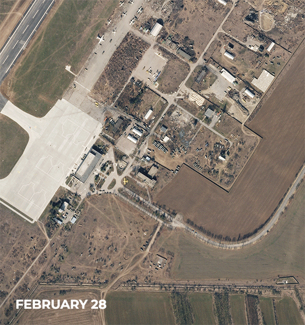 | SkySat • Kherson Air Base, Ukraine • February 28 - March 16, 2022 |
This week, we interviewed Wim Zwijnenburg, a Humanitarian Disarmament Project Leader for the Dutch peace organization PAX and a contributor to Bellingcat, an OSINT investigative journalism group. His work focuses on emerging military technologies and their impact on how wars are being fought and consequences for arms proliferation. We spoke to Wim about OSINT’s role in the war and how he uses satellite data in his own work. Take a read below.
Pictured: SkySat imagery showing a mass grave from which civilians were exhumed in Bucha, a suburb of Kyiv.
|
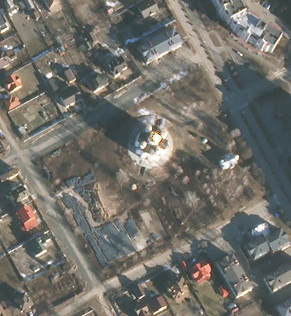 | SkySat • Bucha, Ukraine • March 11, 2022 |
What are some of the ways in which satellite data has aided in your reporting?
Satellite data is an essential tool for near-real time monitoring of conflict-impacts in the Ukraine war. We combined social media information, mostly from Telegram, Facebook and Twitter on conflict events and used satellite imagery to verify the data. But both SkySat and the Planet Dove constellation can be used to track damages directly, either by spotting fires, changes in the landscape or direct damage visible on very high resolution imagery of known sensitive sites that we keep track of.
Pictured: The Mariupol Theater was sheltering hundreds of people when it was struck. |
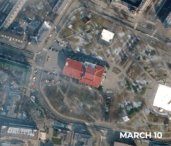 | SkySat • Mariupol, Ukraine • Mar 10 - 21, 2022 |
What does your verification process look like?
Our environmental work often aims to triangulate data as much as possible. Often it starts with reports on damage coming from social media. So we try to geo-locate or identify the location, use remote sensing data (e.g. NASA's VIIRS to spot fires from impacts), public data on the type of location that was targeted to understand what the possible environmental health risks are. For example, is it a factory or warehouse, what type of production does it do, what are the hazardous substances usually processed or stored there? This information is key to understanding the wider risks associated with an attack. Then we'll pull up various imagery, e..g from Planet, but also Sentinel-2, 3, 5P, Landsat 8/9, MAXAR or Airbus images (if available/accessible) and see the scale of the damage. When there is a high level of certainty, we usually publish the information. And sometimes it's also going on the fly trying to make an assessment without imagery (e.g. when there is too much cloud cover for days, but still you want to put info out there) which is a bit more riskier, so sometimes we have to adjust our initial assessment with new imagery available.
Pictured: A downed bridge over the Desna River, southeast of Chernihiv, Ukraine. |
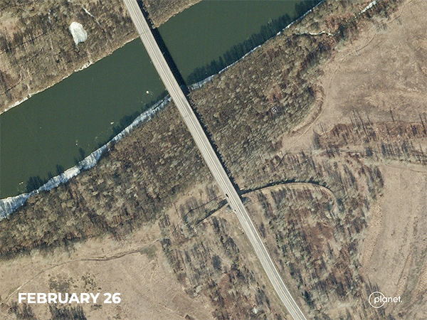 | SkySat • Desna River Bridge, Ukraine • February 26 - 28, 2022 |
What kind of responsibility do OSINT analysts have in active conflicts?
On the internal process: be transparent about the sources of information, as this helps verification and can support other researchers. Next, guide the reader/viewer through your thought and analysis process so others can learn or comment on it. And lastly, give credit where credit is due. In the wider debate, OSINT analysts should be careful on what they publish, in particular around the privacy of civilian victims, as this can be misused or hard to remove once it's online. Also, they have a responsibility to be really thorough in their publications, as information spreads fast. We already saw in the beginning of the conflict that an organization using OSINT for environmental research was disseminating misinformation, failing to double check old imagery shared by others, or more recently, that claims were made about the leaks of chemicals at Mariopul's Azovstal Factory with an image which turned out to be 9 years old, but was quickly doing its round in international media as being a recent image.
Pictured: Smoke rising over Snake Island, a rocky outcrop in the Black Sea that has become a battleground of strategic value. |
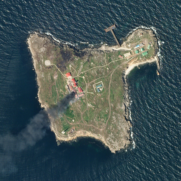 | SkySat • Snake Island, Ukraine • May 6, 2022 |
A lot of your work focuses on the environmental impacts associated with violent conflict. What have you been noticing in Ukraine?
In the first two months, there were a large number of Russian strikes against energy infrastructure, in particular fuel storage facilities, that had local environmental impacts from air and soil pollution. The widespread fighting in and around urban areas also damaged a significant number of industrial facilities, including sites storing or processing hazardous chemicals or other toxic substances, including attacks on ammonia processing plants, paint warehouses, foam production sites. There needs to be ground assessment to understand the environmental impacts of those. There are also more widespread impacts that require more spatio-temporal research including damages to nature reserves, forest and agricultural land.
Pictured: The destruction of a grain elevator in Rubizhne, Ukraine. The war has deepened food insecurity throughout the world. |
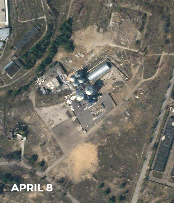 | SkySat • Rubizhne, Ukraine • April 8 - 21, 2022 |
|
In particular the latter, we're likely to see a long-term impact as agricultural infrastructure has been damaged, including farms, fertilizers production sites, storage facilities, but also the land itself contaminated with unexploded ordnance and significant soil disturbance from military movements and damaged irrigation. We're also seeing severe damage to water infrastructure in Ukraine from shelling, including water pumping stations, filtration plants and water treatment facilities, but also dams that have been breached or large areas deliberately flooded.
Pictured: Flooding in Ukraine, which analysts believe to be intentional to stop the advance of Russian troops. |
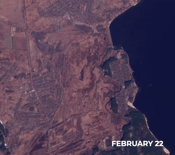 | PlanetScope • Irpin River, Ukraine • Feb 22 - 28, 2022 |
You’ve been using OSINT sources to verify claims, build narratives, and track stories for years in other countries like Iraq and Syria. How has the landscape changed since then with the Russian invasion of Ukraine?
The years of doing environmental open-source monitoring has been helpful in demonstrating the utility of a wide range of remote sensing instruments, which has inspired a wider crowd to also apply this methodology, including news agencies, civil society organisations and activists. We're seeing a broader use, which has been very helpful, but often also shows the difficulty as visual interpretation of satellite imagery remains a skill that needs development. I often made mistakes when starting to use these tools, and still do, but I'm fortunate to be part of the OSINT community that has GIS and OSINT experts that often helped out trying to understand what we were looking at. That takes time and patience, whereas a newer generation of users, as the popularity of and access to these tools has exponentially grown, often jump to conclusions without proper checking. What also changes is new providers and new markets, and the conflict in Ukraine has seen satellite image providers providing a large amount of imagery even prior to the conflict that is helping to both track developments, and strengthens accountability of the warring parties through public means.
Pictured: The expansion of a mass grave near the village of Staryi Krym.
|
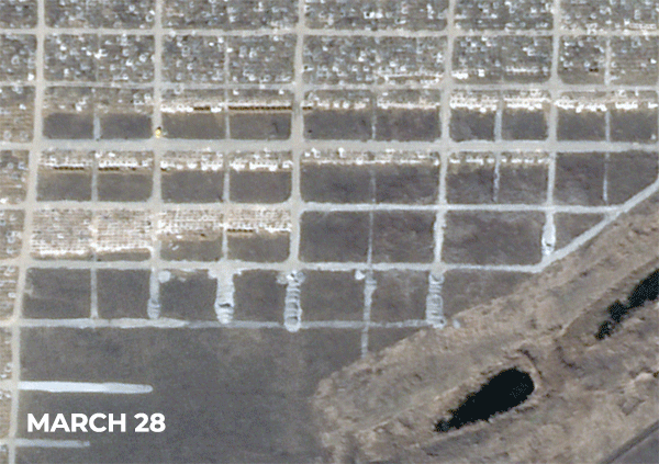 | SkySat • Staryi Krym, Crimea • March 28 - April 25, 2022 |
You can read more of Wim’s articles here and find his Twitter here.
Planet continues to provide imagery to governments, aid and relief organizations, data analysts and the media. Our data is being used to verify what’s happening on the ground, provide greater transparency to the global community, and enable humanitarian response efforts where possible.
Pictured: A dark plume of smoke rising from Chuhuiv Air Base, just outside of Kharkiv, Ukraine.
|
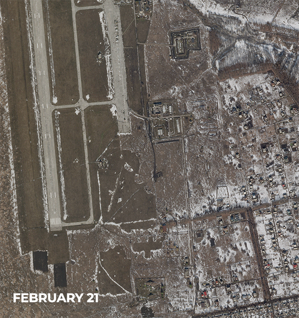 | SkySat • Chuhuiv Air Base, Ukraine • Feb 21 - 24, 2022 |
| |
| |
|
|

