|
|
|
|
|
|
|
APRIL 14, 2022 | ISSUE 21
|
|
|
 |
|
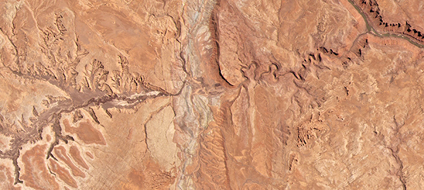
PlanetScope • Arches National Park, Utah • April 19, 2021
|
|
In this week’s issue:
Satellites capture images of National Parks in the US, experts analyze images to monitor nuclear developments in Russia, China, and North Korea, and a copper
mine reveals brilliant blue tailings in Arizona.
|
|
|
|
|
FEATURED STORY
National Parks
|
|
Here are two compatible facts: humans have a natural inclination to view landscapes from their apex and there’s always a higher peak that promises a better view.
These self-reinforcing tendencies push us to extreme heights (like the moon) and to spend our time in search of that exceptional vista.
For those living in the United States, they also drive many of us to the country’s National Parks: Half Dome’s famed summit, Mount Rainier’s haphazard volcanic scenes, the ridge of the Grand Canyon.
While we’re not trying to one-up anyone’s mountaineering photos, our satellites do have the highest views.
And wow are they pretty.
|
 |
|
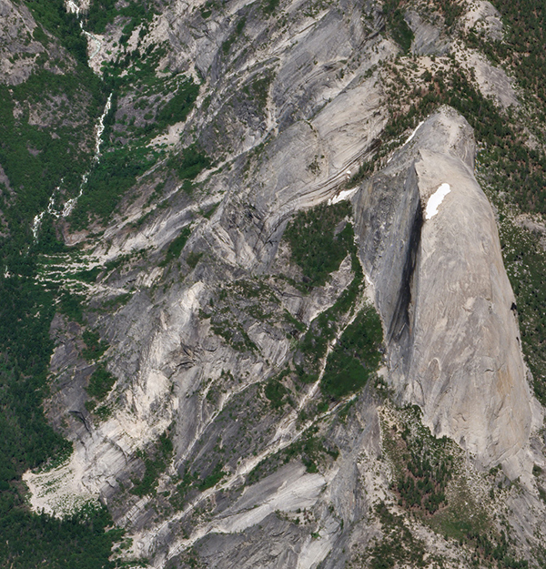
SkySat • Half Dome, Yosemite National Park • June 18, 2019
|
|
It’s about to be National Park Week, so we wanted to share some of our favorite images taken of these spectacular landmarks.
And not just the ones with dramatic heights either.
The lowest point in America is in Death Valley National Park at 282 feet (86 meters) below
sea level.
In between the country’s highest peak and deepest low lie a multitude of rich ecosystems, from tropical marshland to arctic tundra, that contain everything from petrified forests to gypsum sand dunes to active volcanos.
|
 |
|
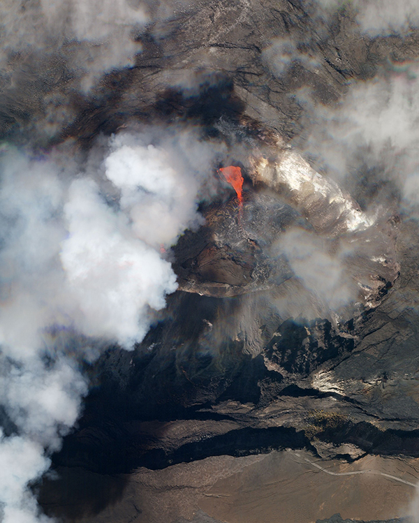
SkySat • Kīlauea, Hawaii Volcanoes National Park • December 21, 2020
|
|
If you’re lucky, maybe you’re one of the tens of millions of people who visit them each month.
Our Dove satellites, however, visit every day.
So they’ve picked up some beautiful sights over the years.
While we’d argue that the only way to truly experience their charm is by visiting in person, we think marveling at these wonders from space only enhances the experience.
|
 |
|
PlanetScope • Everglades National Park, Florida • November 24, 2021
|
|
There are over 400 national park sites, but only 63 have the capitalized status of being a National Park.
Yellowstone became the country’s first in 1872.
And in the 150 years since then the government has expanded these protected areas to 84 million acres, a size that would make it the 5th largest
state on its own (displacing New Mexico, which has 2 National Parks).
The parks are located across 30 states and 2 US territories, with California in the lead at a total of 9.
|
 |
|
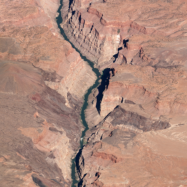
SkySat • Lava Falls, Arizona • October 12, 2019
|
|
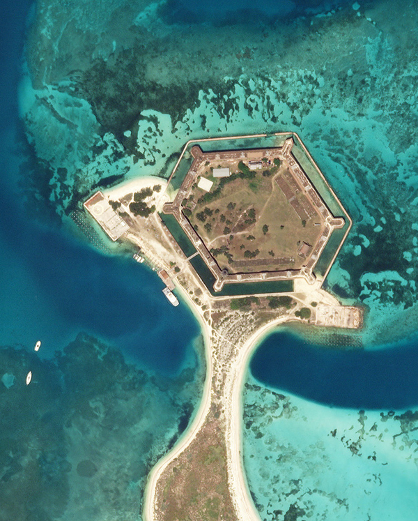
Scooch a little farther down from Everglades National Park and you get Dry Tortugas, an aquatic turtle haven with a puzzling adjective in its name.
Coral reefs known for wrecking ships surround the area’s islands.
And there’s even a hexagonal 19th century fort presiding over the archipelago.
As it turns out, the middle scutes of a sea turtle’s shell are also hexagonal, which is pretty adorable when you think about it.
|
 |
|
SkySat • Dry Tortugas, Florida • May 2, 2019
|
|
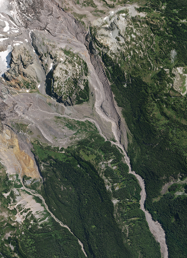
Most cities’ skylines are made of skyscrapers.
But Seattle’s also has one giant mountain.
Mount Rainier is the tallest peak in Washington with an iconic snow-capped crest visible for miles around.
Oh, and it’s an active volcano.
This image shows how its biome moves from wintry bare mountaintop to temperate forest down its slopes.
|
 |
|
SkySat • Mount Rainier, Washington • August 19, 2019
|
|
|
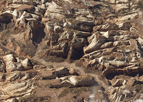
Zion is famous for its 15-mile long (24 km) and 2,000-foot (610 m) deep canyon.
It’s got rock formations sure to keep geologists entertained for hours (at minimum) and death-defying hikes for anyone bold enough to try.
|
 |
|
SkySat • Zion National Park, Utah • March 12, 2018
|
|
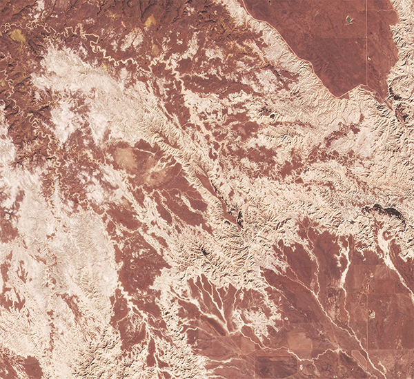
Apparently there’s a lot of geologists who read Snapshots (you all rock), so here’s some more mineral content for you all! The rocky formations of South Dakota’s Badlands National Park were
built by deposition over the brief period of 75 million years ago.
It’s a hot spot for fossils and paleontologists have even discovered rhinoceros
remains there.
|
 |
|
PlanetScope • Badlands National Park, South Dakota • March 25, 2022
|
|
Next week is not just National Parks Week but also Earth Day! So we’ll have extra amazing Earth images for you in the next issue.
In the meantime, we hope you get outside and enjoy the nature around you, whether it’s a National Park, a normal park, or the highest peak you can find.
|
 |
|
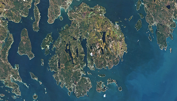
RapidEye • Acadia National Park, Maine • October 17, 2010
|
|
|
|
No Fighting in the War Room
|
|
More or less at the same time that these natural areas were marked for preservation, new breakthroughs were made into the atom-splitting science that would lead to the rise of the nuclear age.
And monitoring the 13,000
nuclear warheads across the 9 nations that possess them now is paramount during this period of heightened geopolitical tensions.
|
 |
|
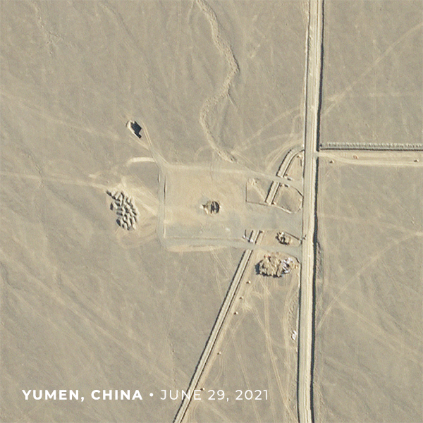
SkySat • Silo development, Yumen, China • June 2021 - April 2022
|
|
|
Open-source intelligence analysts jumped into action when Putin postured Russia’s nuclear arms in late February.
In The New York Times’ article titled “How America Watches for a Nuclear Strike,” science journalist and senior
writer William J.
Broad explains how US experts watch foreign atomic developments and prepare defenses accordingly.
In the age of accessible information, surveillance is key.
And satellites offer a transparent look at on-the-ground activity in particularly sensitive areas like China, North Korea, and Russia.
|
 |
|
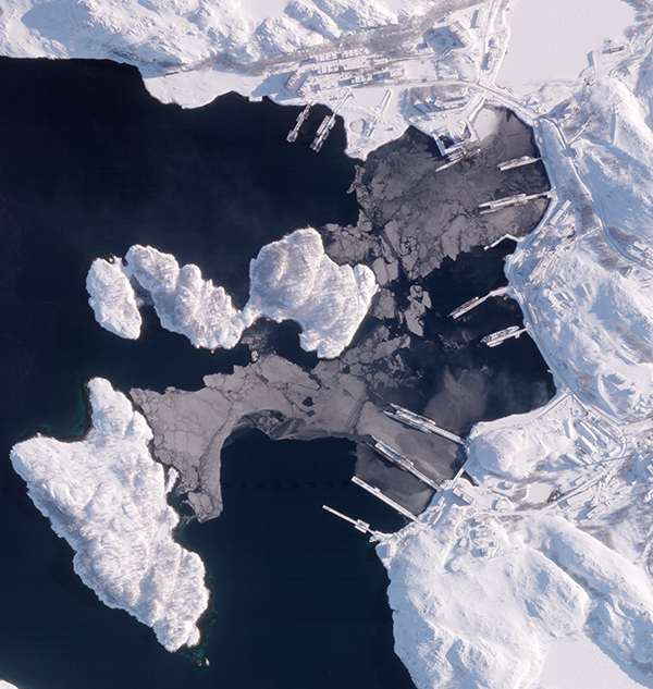
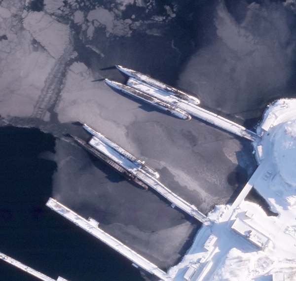
SkySat • Gadzhiyevo, Russia • March 7, 2022
|
|
One of Russia’s most powerful military assets is its fleet of nuclear submarines, which stealthily patrol the seas and offer a compelling deterrence strategy.
Jeffrey Lewis and Michael Duitsman at the Middlebury Institute of International Studies at Monterey (MIIS) have been watching Russia’s Gadzhiyevo submarine base in the arctic to see if any submarines had left port.
No submarines present could signal trouble, since it implies they’ve moved to a ready position.
By monitoring the ports at base they can keep an eye on Russia’s day-to-day moves and deduce intent based on the information in the images.
As of March 7th, their analysis of satellite imagery suggests that the nuclear submarines are docked.
|
 |
|
SkySat • Gadzhiyevo, Russia • March 7, 2022
|
|
As Russia’s invasion of Ukraine unfolds, weariness and concern over nuclear escalation within other countries has intensified.
Over the past few months, analysts have watched China construct over 100 suspected
missile silos near Yumen.
The latest images indicate that the last of the temporary covers—those bounce-house looking bubbles above—were removed.
This suggests that the sensitive work China was concealing is complete.
And elsewhere in the world, MIIS researchers found signs of tunneling near an underground North Korean nuclear test site in
satellite images.
Like a Geiger counter for nuclear infrastructure instead of radiation, satellite images, when paired with expert analysis, can help keep a pulse on nuclear developments and pick up on political changes.
|
|
|
|
|
|
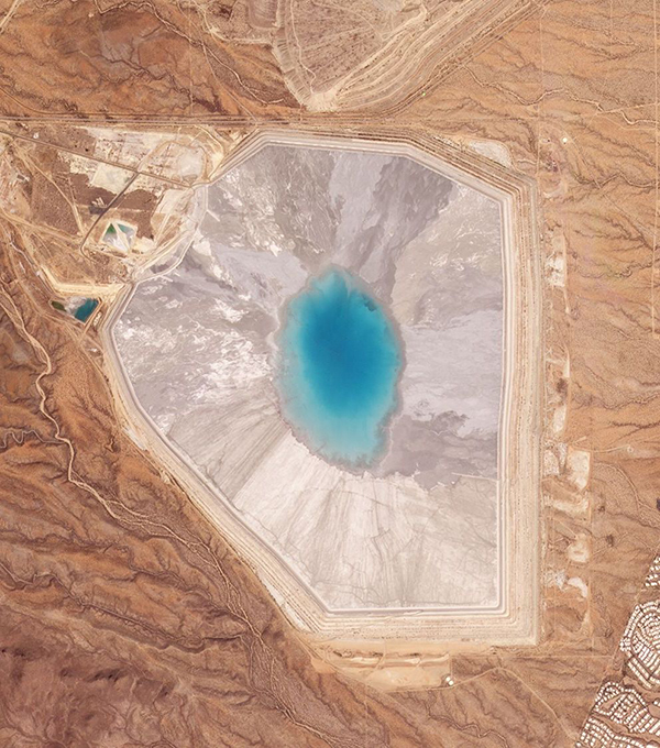
Sierrita Mine Tailings
|
|
It’s frustrating that chemically toxic mine tailings look so welcoming for a swim.
But don’t let the Caribbean-blue pool of Arizona’s Sierrita Mine fool you.
These waters are filled not with coral but with remnants of copper ore.
Mine tailings are the waste runoff produced after a target resource has been extracted from ore.
We spot a lot of them around the world and are enamored with their vibrant coloring.
Have any favorites? Let us know and we’ll take a look!
|
 |
|
PlanetScope • Sierrita Mine, Arizona • March 27, 2022
|
|
|
|
|
|
|
|

