 |
 |
|
SkySat • Antarctica • February 20, 2022
|
|
In this week's issue: A ship sets sail to uncover the Endurance shipwreck (and more) in Antarctica, satellite imagery shows Russia's ongoing invasion of Ukraine, and a SkySat spots some
rainbow-tinged wind turbines in Wales.
|
|
|
|
|
FEATURED STORY
Antarctic Voyage
|
|
Our satellites can't see into the depths of the ocean, but they can see the ships on its surface that are exploring the deep.
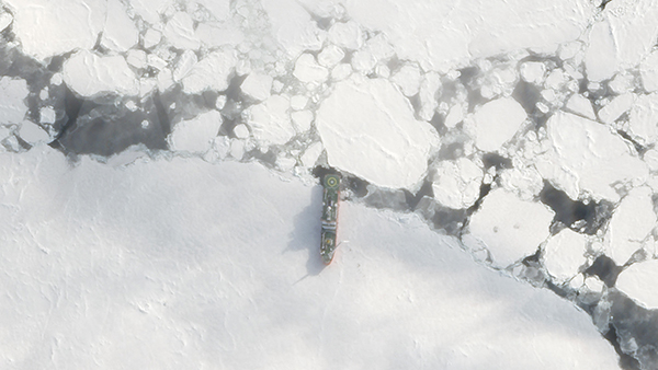
Last month, the ice-breaking vessel S.A.
Agulhas II set out on the Endurance22 expedition in Antarctica's Weddell Sea.
The mission? To find the legendary Endurance shipwreck.
In 1914, Ernest Shackleton and his crew attempted to cross Antarctica on the Endurance but were stranded when their ship was caught in an ice floe.
What followed was an epic tale of survival in harsh Antarctic conditions and an ice-battered wreckage left at the bottom of the sea.
|
 |
|
SkySat • S.A.
Agulhas II, Antarctica • February 20, 20
|
|
Over a hundred years later, the explorers aboard S.A. Agulhas II are sailing in the Endurance's figurative wake.
But this time they aren't using sextants and chronometers.
The Endurance22 expedition is equipped with state-of-the-art tech, like underwater drones that scan the seafloor for signs of the wooden shipwreck.
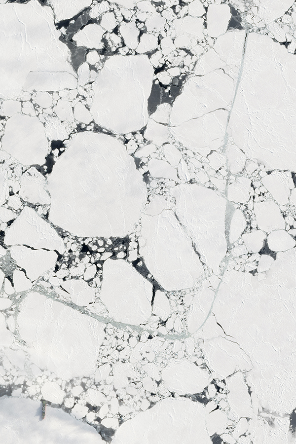
As they sail aboard a ship that can break through meter-thick ice at 5 knots, the crew is better prepared to handle what Shackleton called "the worst portion of the worst sea in the world."
Pictured below is the S.A. Agulhas II (bottom left) with a path cut through the ice behind it:
|
 |
|
SkySat • S.A.
Agulhas II, Antarctica • February 20, 2022
|
|
But the 100+ person crew and team of scientists, meteorologists, and researchers aboard the S.A. Agulhas II are also in search of a more alarming discovery: how greenhouse gas emissions are changing the Antarctic ice pack.
The remote continent is home to around 90% of Earth's ice.
And it's melting.
Fast.
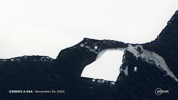
Antarctica is losing ice three times as much as it was in 2007, with all that excess meltwater running into the ocean and raising global sea levels.
|
 |
|
SkySat • Antarctica • November 29, 2020
|
|
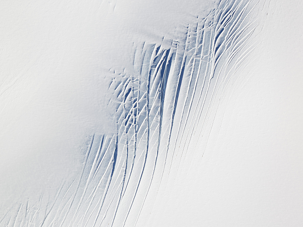
Glaciers like Thwaites, nicknamed the 'Doomsday Glacier' due to its potential to release
massive amounts of water into the ocean as it warms, are especially concerning.
Scientists are carefully studying how glaciers and ice sheets are changing.
And satellite data is an important resource for monitoring these frozen domains.
|
 |
|
SkySat • Thwaites Glacier, Antarctica • December 21, 2021
|
|
The Endurance—shipwrecked and buried under harsh sea and ice—was designed to make the first land crossing over Antarctica.
But the voyage's legacy lies in Shackleton and his crew's perseverance and epic fight for survival.
Perhaps the crew aboard S.A. Agulhas II will find the shipwreck and add a new chapter to its storied history.
But what the expedition—and all the other researchers around the world—discovers about how we're altering Earth's icy continent may turn out to be the story that lives on.
Follow along the Endurance22's journey on their Twitter account and check out more information about the voyage on their website!
|
|
|
|
Ukraine Update
|
|
Over the past week Russia has launched a full-scale invasion of Ukraine, entering the country from multiple fronts, bombarding many regions, and encircling major cities.
The attack has caused a major humanitarian crisis and global repercussions.
Last Thursday we shared how open-source intelligence—from satellite imagery to TikTok—has been used to monitor Russia's buildup of troops along the Ukrainian border.
As Russian forces enter the country and begin their attack, accessible data continues to play a vital role in providing information to the public.
Here are some key developments we've captured this past week.
|
 |
|
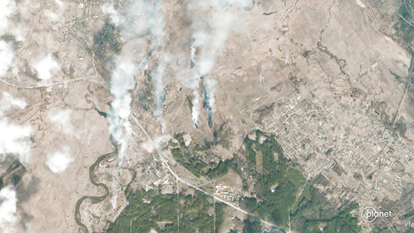
PlanetScope • Ivankiv, Ukraine • February 25, 2022
|
|
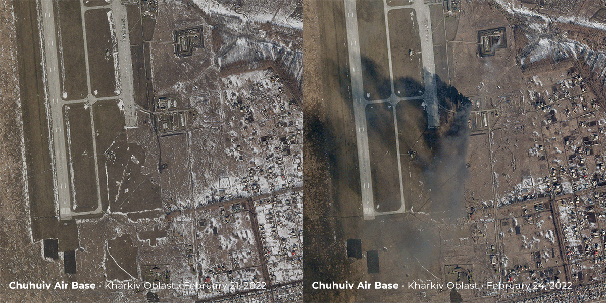
On February 24th, smoke can be seen rising from Chuhuiv Airbase outside of Kharkiv after an attack.
|
 |
|
SkySat • Chuhuiv Air Base, Kharkiv Oblast, Ukraine • February 21 - 24, 2022
|
|
During the military buildup last week, a bridge's construction played a pivotal role
in revealing Russia's intentions.
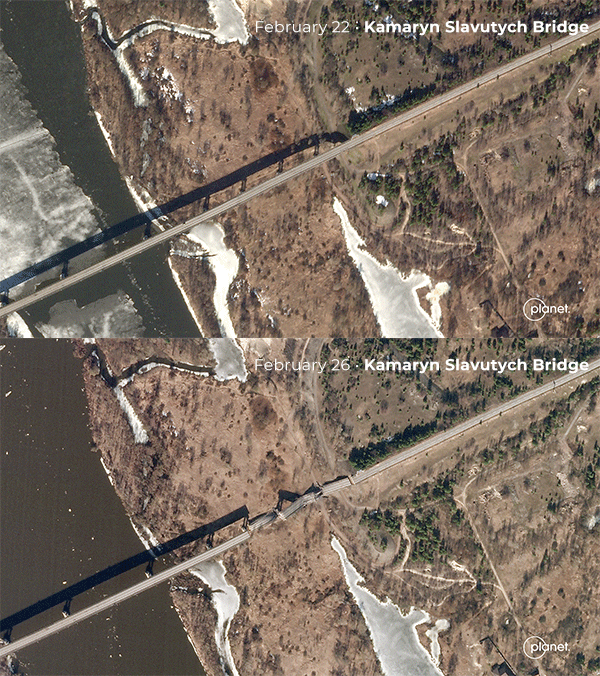
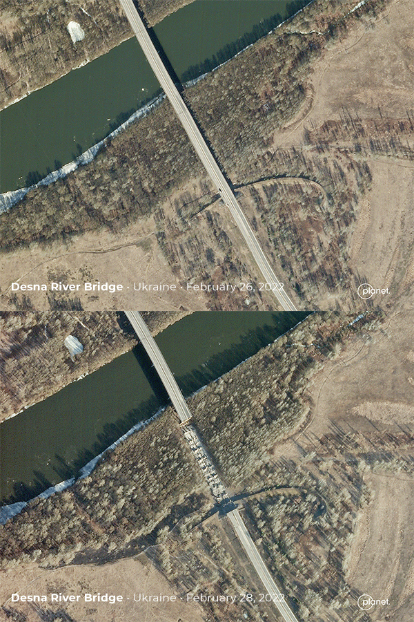
This week, two bridges were destroyed: the Kamaryn Slavutych bridge on the Ukraine-Belarus border and a bridge over the Desna River, south of the city of Chernihiv, Ukraine.
|
 |
|
SkySat • Kamaryn Slavutych Bridge, Ukraine-Belarus border • February 22 - 26, 2022
|
 |
|
SkySat • Desna River Bridge, Ukraine • February 26 - 28, 2022
|
|
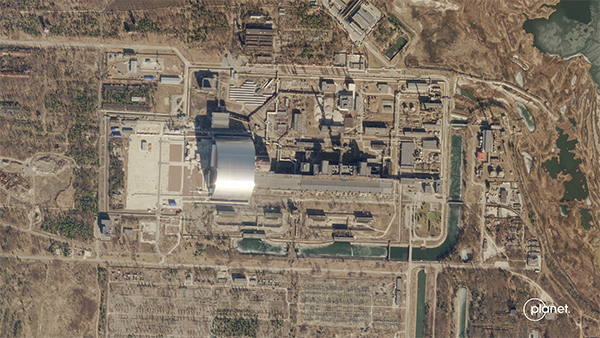
Russia took control of the Chernobyl power plant—where the world's worst nuclear disaster took place in 1986—prompting concerns over radioactive safety.
|
 |
|
SkySat • Chernobyl, Ukraine • February 26, 2022
|
|
Russia's presence was noted outside of Ukraine as well.
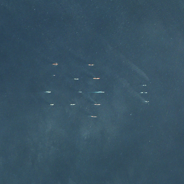
The country's navy was spotted in the Mediterranean Sea moving in formation towards Tartus, Syria.
|
 |
|
PlanetScope • Russian Navy, Mediterranean Sea • February 24, 2022
|
|
What we see unfolding in Ukraine is tragic.
Planet has, is, and will continue to provide imagery to our partners in governments, aid and relief organizations, data analysts, and media.
We are committed to transparency and accountability and will continue to help those who will leverage our services in timely and responsible ways given the rapidly-changing landscape.
|
|
|
|
Rainbow Turbines
|
 |
|
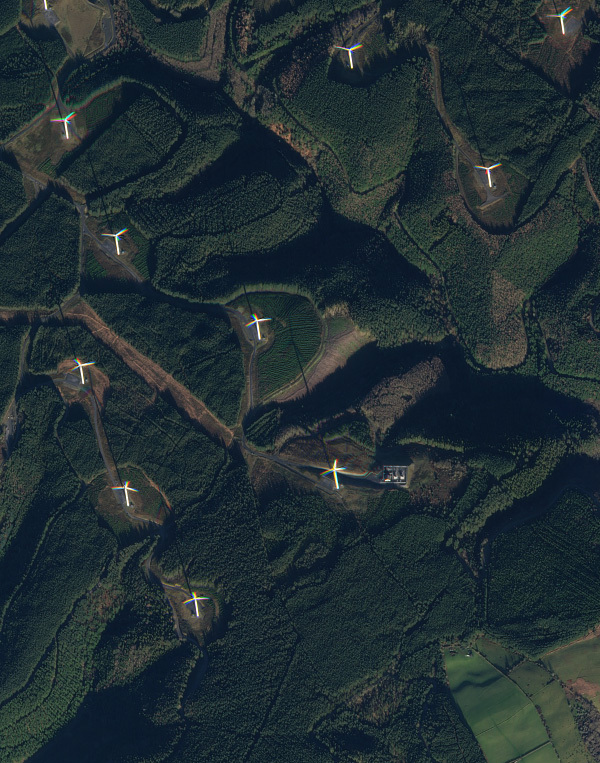
SkySat • Wind Farm, Wales • December 5, 2021
|
|
There may not be a pot of gold at the end of the rainbow, but our satellites say there's at least a few megawatts of energy there.
We did a satellite explainer on it in Issue #8, but for the new folks here we'll explain this fun feature again.
|
 |
|
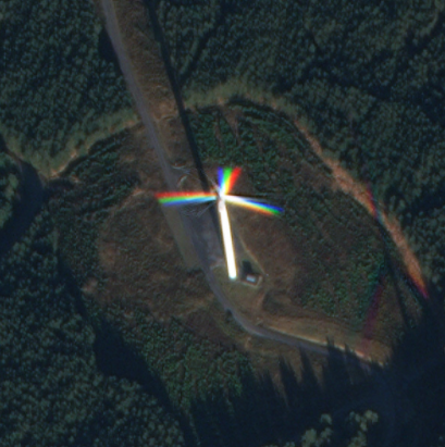
SkySat • Wind Farm, Wales • December 5, 2021
|
|
Our satellites usually photograph still-objects (like terrain and structures) by combining three images of a scene in red, blue, and green.
But during the capturing sequence, fast-moving objects like planes or wind turbines change locations between each shot.
The result is a composite image in which the static parts appear normal but the moving parts are rendered as a succession of single-colored outlines.
|
|
|
|
|
|
|
|
|
|